


On television broadcasts and forecast maps, hurricanes appear as two-dimensional swirling vortices, belying their extremely complex three-dimensional structure. Being able to peer past the tops of clouds to see what’s happening inside a storm is critical for forecasting—particularly for catching one that is about to rapidly intensify into something more dangerous. But a key source of data that provide an x-ray-like view of that structure will shut down by June 30, just before hurricane season tends to kick into high gear.
“It’s certainly one of the more important data sources that we have because it provides a unique dataset,” says James Franklin, former chief of the National Hurricane Center’s (NHC’s) Hurricane Specialist Unit. “It’s the only way really to see through clouds and get a sense of the organizational structure of the core of a developing cyclone.” Having that information can alert forecasters to rapid intensification or other major changes hours before they become apparent in other data—providing crucial time to warn people in harm’s way.
This view into storm structure comes from sensors onboard Defense Meteorological Satellite Program (DMSP) satellites. Those data will no longer be taken up, processed and sent out to the National Hurricane Center or other non-Department of Defense users. The exact reasons for the shutoff are unclear but appear to be related to security concerns.
On supporting science journalism
If you’re enjoying this article, consider supporting our award-winning journalism by subscribing. By purchasing a subscription you are helping to ensure the future of impactful stories about the discoveries and ideas shaping our world today.
“The timing [of the shutdown] could not be worse as far as hurricane season is concerned,” and it comes along with other recent cuts and limitations to the National Oceanic and Atmospheric Administration, says Kim Wood, an atmospheric scientist at the University of Arizona.
What do microwave data tell us about hurricanes?
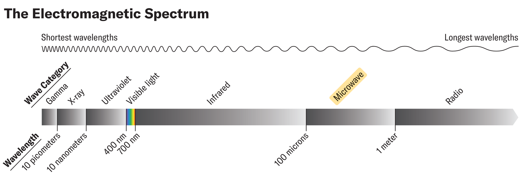
Satellites orbiting the Earth gather data in multiple wavelengths of light: visible, infrared, microwave, and so on. Each provides different kinds of information. Most people typically see images of hurricanes in the visible part of the electromagnetic spectrum, but the storms also emit microwaves. “Everything is emitting microwaves,” Wood says. “We’re currently emitting microwaves sitting here. And it’s because our temperatures are above absolute zero.”
Microwaves are useful in monitoring hurricanes, Wood says, “because the waves are so long they get through the tops of the clouds.” This lets forecasters see a storm’s inner workings—particularly changes to its eye and eye wall (the circle of clouds that surround the eye and make up the strongest part of the storm). Such changes can indicate if a hurricane is strengthening or weakening.
This is a particularly useful tool for monitoring storms at night, when visible satellite imagery is unavailable. Though infrared data are available at night, microwave data have 16 times their resolution, Wood says. Being able to watch a storm overnight can help avoid what Franklin calls a “sunrise surprise”—when forecasters get the first visible imagery at daylight and find that the storm has become much stronger or better organized than they had expected.
Microwave imagery is particularly useful for catching rapid intensification—defined as when a storm’s winds jump by at least 35 miles per hour in 24 hours. Forecasters using microwave data can catch the process and warn people faster than they could otherwise. This was the case with Hurricane Otis in 2023, which was the first known Category 5 Pacific hurricane ever to make landfall and caused significant devastation. Microwave “satellite imagery clued us in to the potential for this system to be really strong,” Wood says.
Microwave data are also extremely useful in locating the center of weaker storms. These storms tend to lack a central eye and eye wall, and clouds higher in the atmosphere can obscure where those located lower down are circulating in visible imagery. Knowing where the center of the storm lies is important information to feed into hurricane models that forecast where the storm will go. Feeding microwave data into models can improve the accuracy with which they determine the position of the center of a storm by about 60 miles, Franklin says—noting that an incorrect position is “going to cascade or leak into your track forecast.” This means that meteorologists who lack microwave imagery may not be able to forecast where a storm will make landfall as accurately as those who have it.
Where do microwave data come from, and why were they cut?
Because the microwaves emitted from Earth’s surface and atmosphere are very weak, they can only be detected by satellites in very low-Earth orbit, Wood says. (The geostationary satellites that provide visible imagery orbit farther out. To have a sensor big enough to detect microwaves from their position, they would need to be the size of the Death Star, Wood says.) But because those microwave-detecting satellites orbit so close to Earth, they see less of it at any given time than geostationary satellites do—so more of them are needed to adequately monitor the planet. And there are longer time gaps between when a microwave-detecting satellite “revisits” the same spot.
That means microwave data are already limited. There are currently six satellites providing that information for U.S. weather forecasting purposes, and they are only useful for hurricanes if they serendipitously pass overhead at the right time. But now three of them are about to be turned off. “That’s a big drop in the availability of this tool,” Franklin says.
The data that are about to be lost come from what are called Special Sensor Microwave Imager Sounder (SSMIS) sensors onboard three DMSP satellites. The exact reason for the shutoff is unclear, though some reports have cited security concerns. It does not appear that the concerns are with sharing the data themselves or with funding the collection and dissemination of that information.

Infrared satellite imagery of Hurricane Otis compared to microwave imagery. In the later, the center of the storm is more visible and indicates the hurricane was strengthening.
In an e-mail to Scientific American, a spokesperson for the U.S. Space Force wrote that “DMSP satellites and instruments are still functional” and that DOD users will continue to receive the data. They referred further questions about the decision to the U.S. Navy, which had not replied to requests for comment by press time.
In an e-mail to Scientific American, Maria Torres, a spokesperson for the NHC, wrote that “the DMSP is a single dataset in a robust suite of hurricane forecasting and modeling tools in the NWS portfolio.” She cited other satellites, ocean buoys and the Hurricane Hunter flights, among other tools. “NOAA’s data sources are fully capable of providing a complete suite of cutting-edge data and models that ensure the gold-standard weather forecasting the American people deserve,” Torres wrote.
There are other satellites that could theoretically provide microwave data—including a recently launched DOD satellite—but there has been no discussion of making those data broadly accessible, Wood says. And because forecasting models and other systems are geared toward the existing data, it is not simple to use a new data source as a substitute. “It’s one thing for a satellite to exist,” Woods say. “It’s another thing for us to be able to access it.”
What we can expect this hurricane season
The loss of these data is most concerning when it comes to storms that are relatively far out in the ocean (beyond the range of Hurricane Hunter aircraft) and to storms in the Pacific Ocean, where fewer such missions are flown. There are typically more monitoring flights for storms that are a threat to the U.S., particularly as they get close to land. But two thirds of all hurricane advisories are issued based solely on satellite data, Franklin says.
The loss of these data alone would be extremely concerning for forecast accuracy this hurricane season—but it comes on top of the broader cuts that have already been made to the National Weather Service and NOAA. For example, there may be fewer launches of the weather balloons that help illuminate how the larger atmospheric environment will steer a storm. And it is unclear if Hurricane Hunter flights might be affected. “Losing this data is worse than it might have been a year ago,” Wood says.
“It’s pretty much guaranteed that there will be some forecast this year where significant intensification, most likely of a tropical storm [to a hurricane], is missed by six to 12 hours because these data weren’t available,” Franklin says. If it is a Pacific Coast storm, this could be devastating for communities in the way. And even if it is out at sea, it is a big concern for mariners. “Ships go down in hurricanes,” Franklin says.
All in all, “there are a lot of things that are working against forecasting” this year, he says.